Mapping Australia’s orchards for improved industry decision-making
Australia’s tree crop industry has a new online tool to enable quicker and more targeted biosecurity and disaster planning and responses.
Click here to view the Australian Tree Crop Rapid Response Map, part of a $3.4 million project from the Australian Government’s Rural R&D for Profit program.
This project will help macadamia, avocado and mango growers make important decisions around fruit and nut quality and yield, and monitor tree health including early detection of pests and disease outbreaks.
To find out more, you can read the Australian Government media release by clicking here and the Hort Innovation release here.
The Australian Tree Crop Response Map displays the location and extent of all commercial avocado, macadamia and mango orchards in Australia. This will assist natural disaster recovery efforts and biosecurity planning and responses, and together with other components (developed in the wider project discussed below) help growers and industry make important decisions on-farm. You can read more here.
The background
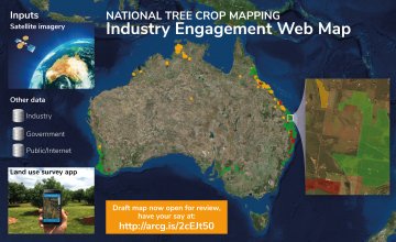
A collaborative team from four universities, government agencies, industry partners, grower groups and commercial providers have developed a new interactive web map of selected horticulture tree crops across Australia. The draft mapping integrates satellite imagery with industry and government data, regional surveys and on-ground evaluations to map the location and area of every commercial (>2ha) avocado, macadamia and mango orchard across Australia.
Launched earlier this month and now open for review, the Industry Engagement Web Map provides stakeholders, growers and experts from the avocado, macadamia and mango industries an opportunity to review and improve the draft map.
How will the Web Map be used?
The Web Map and its associated data will be used by industry to develop a better understanding of changes in Australian avocado production regions. Such information supports improved marketing decision-making and underpins improved biosecurity and post natural disaster response and monitoring.
For example, in the event of a disease outbreak industry groups can access the map and know exactly where surrounding crops are and quickly develop management strategies. The product can also be used to map disasters like floods, fires and cyclones and speed up applications for recovery assistance. In fact, the map is already providing critical information to the natural disaster response and recovery effort in the wake of the devastating Category 4 Tropical Cyclone Debbie which crossed the Queensland coast on Tuesday 28th March.
How you helped
Stakeholders viewed the draft mapping, comparing it with their own local knowledge and providing comments and feedback. Comments were submitted if the information was missing, incorrect or misclassified using an easy pop-up window with predefined options in drop-down menus live within the Web Map.
Stakeholders also used the free Land Use Survey app (iOS and Android) to inform the classification of tree crops by capturing GPS-coded point observations and photos. Comments and data collected via the map and app will be interpreted before the final mapping products are compiled and released in 2017.
Australia’s multiscale monitoring tools for managing Australian tree crops project
The Web Map is the first component of Multi-scale monitoring tools for managing Australian tree crops project, an ambitious project that combines innovative technologies such as satellite mapping, laser scanning and on ground robotics with citizen science apps to deliver improved industry information and methods of monitoring tree health, productivity and quality.
The project was funded through the Australian Government’s Rural Research and Development (R&D) for Profit Grants Programme, managed by Hort Innovation and coordinated by the University of New England. The success of the project can be attributed to the multi-disciplinary team from industry, research/academia and government, including The University of Queensland, University of Sydney, Central Queensland University, Agtrix Pty Ltd, the Queensland Department of Agriculture and Fisheries, Queensland Department of Science, Information Technology and Innovation, Simpson Farms Pty Ltd, Avocados Australia, Australian Macadamia Society and Australian Mango Industry Association.
Date Published: 28/04/2017